
Hike 54 in Hiking Maine is the Debsconeag Backcountry. It’s a great hike that visits several of the Debsconeag Lakes (there are eight) and crosses several ledgy hills with nice views. It’s one of the best hikes in Maine to see wildlife—both because of the topography and the relative isolation. But this isn’t the only hike in the area. In fact, the trail system is a figure eight with trailheads in the southeast and the west. The western loop is even more remote and less visited than the eastern loop.
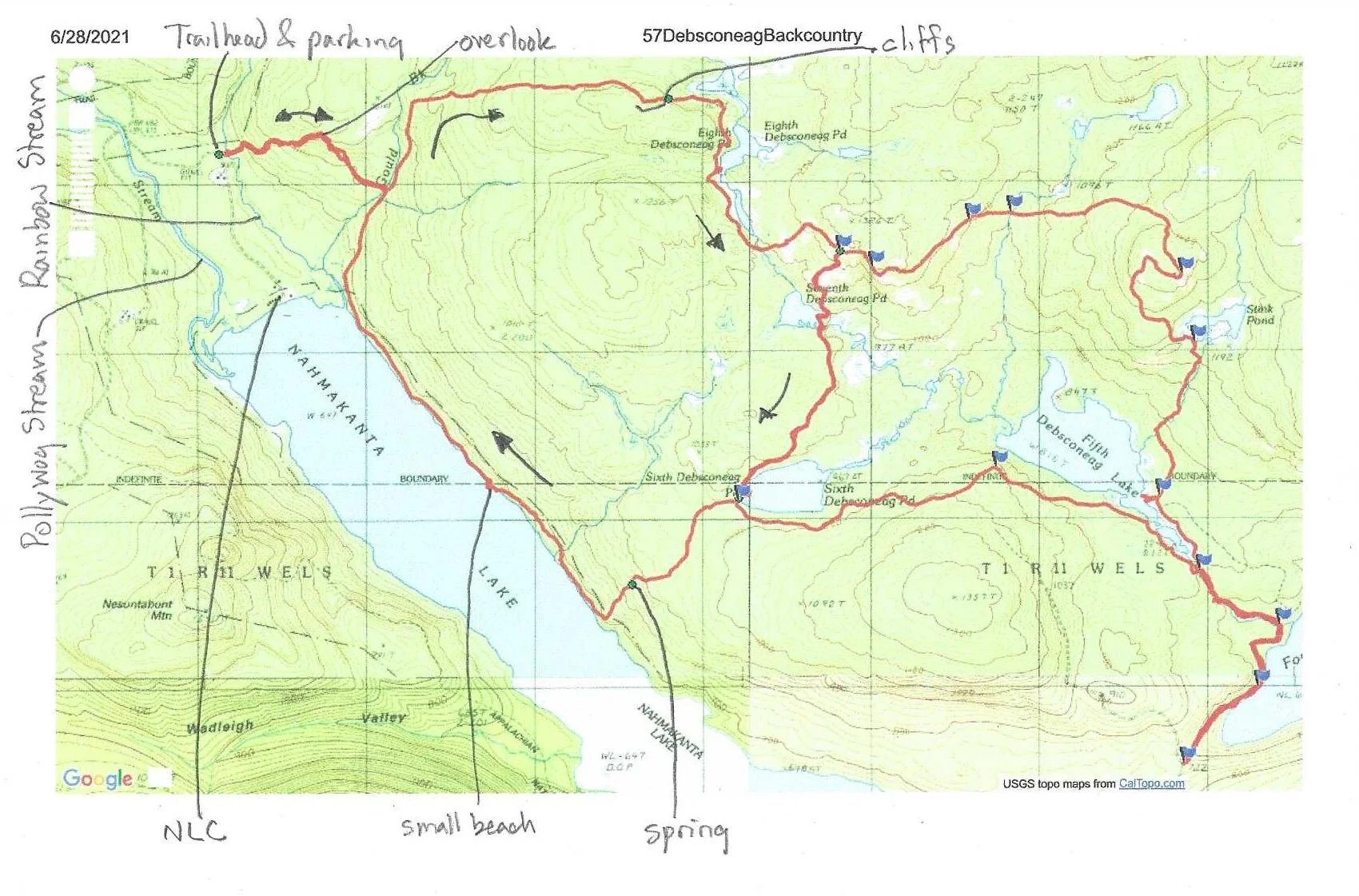
The western loop starts near the end of the Wadleigh Pond Road, more than 25 miles from the Jo Mary gate house. To get to the trailhead, drive north on ME11 out of Brownville. Drive Drive 15.7 miles from the bridge over the Pleasant River. Turn left onto Jo Mary Road (at the sign for Jo Mary Campground). Drive 0.1 mile. Stop and pay the entrance fee. Continue on Jo Mary Road. Drive another 6.0 miles. Turn right, staying on Jo Mary Road. Drive 16.2 miles. Pass the parking for the Turtle Ridge and Tumbledown Dick Trailheads. Continue another 3.9 miles. Turn right at the intersection onto Wadleigh Pond Road. Drive 5.2 miles, passing the Nahmakanta Lake Road, two campsites, and the unmarked road to Pollywog Falls. You will come to a small parking area on the left, then cross the Appalachian Trail. Continue driving for another 2.0 miles. You will pass another parking area on the right, then the AT joins the road. Cross Pollywog Stream. Across the bridge, turn right (the AT goes straight). Drive 1.0 mile toward Nahmakanta Lake Camps (all along the drive, you’ll have seen small signs with NLC on them directing you this way). The parking area for the hike is on the right. There is an information sign with maps. Across the road is the signed trailhead.
The hike is a 9.0 miles lollipop with 1531 feet of climbing. (If you add up the milage on the state’s map, you get 7.5 for the loop. The section from Sixth Pond to and along the lake is longer than listed on their map as is the section from Gould Brook to Seventh Pond.) There are no big climbs, just lots of little ups and downs. The trail is well-blazed and maintained. A lot of the treadway is rocks and ledges, but a fair amount it dirt. It is an excellent hike for spring wildflowers, including trilliums, lady slippers, hobblebush, blue bead lilies, and others.
0.0 200 feet from the trailhead, the trail fords Rainbow Stream. In the summer, the water is only a few inched deep with a washstone bed. In spring the stream is a waist-deep torrent. Plan your hike accordingly. Whatever the season, you can’t cross without getting your feet wet. I bring watershoes and a towel and leave then near the crossing to be picked up on my return.

Emma fording Rainbow Stream
0.1 The trail crosses several dry channels of Rainbow Stream, then climbs out of the valley.
0.5 The trail climbs through a rock garden and up onto a ledge with a vew west of Nahmakanta Lake and Nesuntabunt Mountain. This section is typical of the first half of the hike, which is charaterized by huge boulders in the woods, ledges, low cliffs, and rock gardens.

Nesuntabunt Mountain from the first ledge

Emma hiking past one of the boulders
0.9 Descend gently through the rocky woods to an old, mossy bridge over Gould Brook.Cross the bridge and turn left.

2.3 Climb gently then roller-coaster along a wooded ridge. You pass two blazed but un-signed trails on the left that go to Gould Pond. You pass several ledges and cliffs. The last one is the highest and has an overhanging section.

2.4 Descend steadily to a beaver flowage at the head of the Debsconeag Lakes chain.
2.6 Reach Eighth Debsconeag Pond.

Eighth Debsconeag Pond
3.0 Pass a second beaver flowage downstream from Eighth Debsconeag Pond.

3.2 Cross the outlet stream and climb up toward the ledges.
3.3 Reach the first ledges.
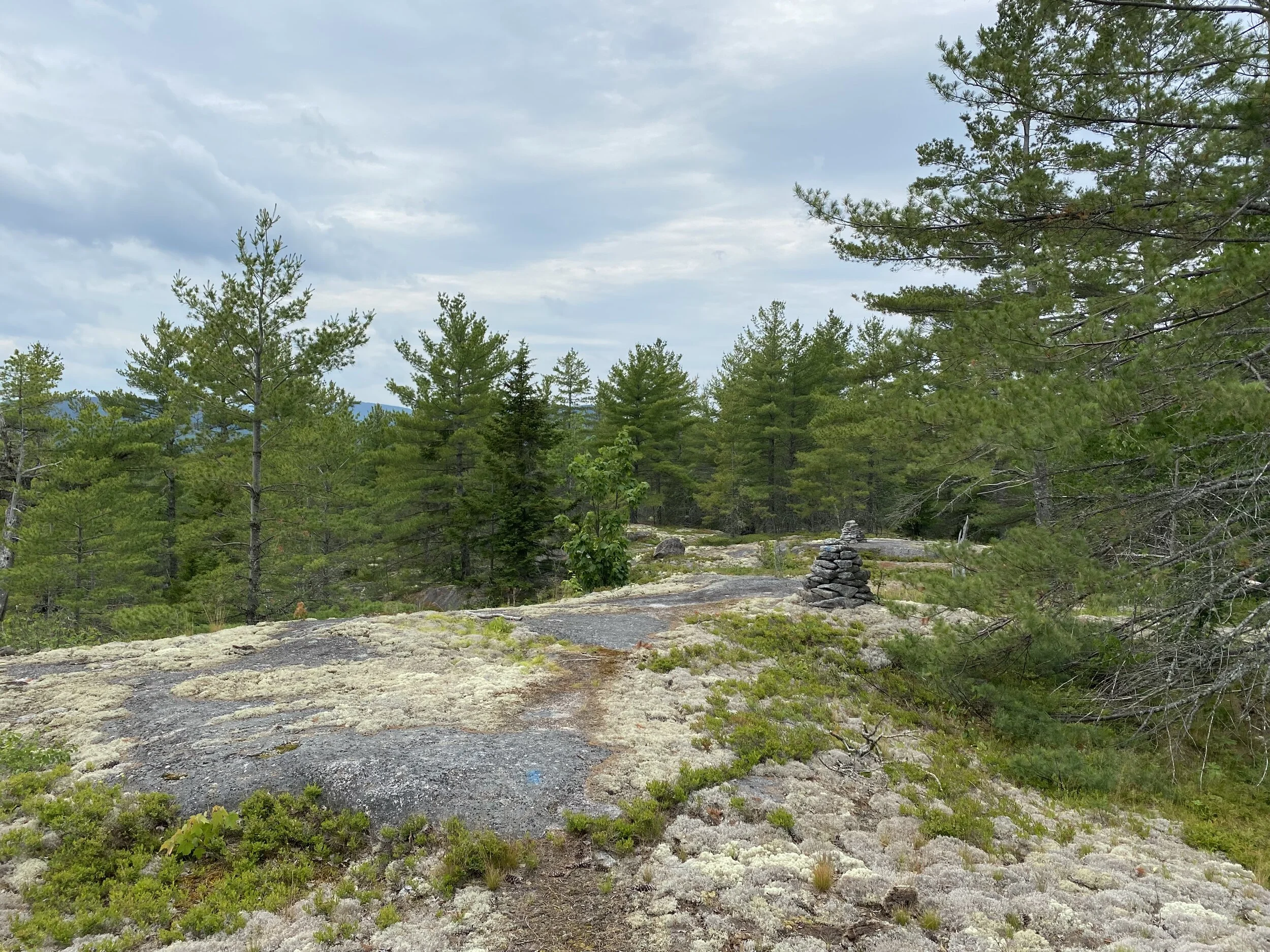
3.6 Rollercoaster along the ledges, tending up to the high point on the hike at an intersection. You have some partial views along this section. Turn right and descend steadily.
4.0 Descend steadily on ledges with some fine views to Seventh Debsconeag Pond.

Seventh Debsconeag Pond
4.1 Cross the outlet stream.
4.9 Cross through hardwood forest to Sixth Debsconeag Pond. A side trail leads 200 feet to the ledgy shore of the pond.

Emma on the shore of Sixth Debsconeag Pond
5.0 Turn right at an unsigned intersection.
5.6 Descend through the woods to a rocky gorge with a spring in it. The spring creates a mossy brook that flows down to the floor of the ravine and then disappears (the water emerges in a marshy area another tenth of a mile on).

The rocky gorge
5.8 Descend to the shore of Nahmakanta Lake.
6.5 The trail turns right and follows the shore of the lake, passing a small, hidden beach.
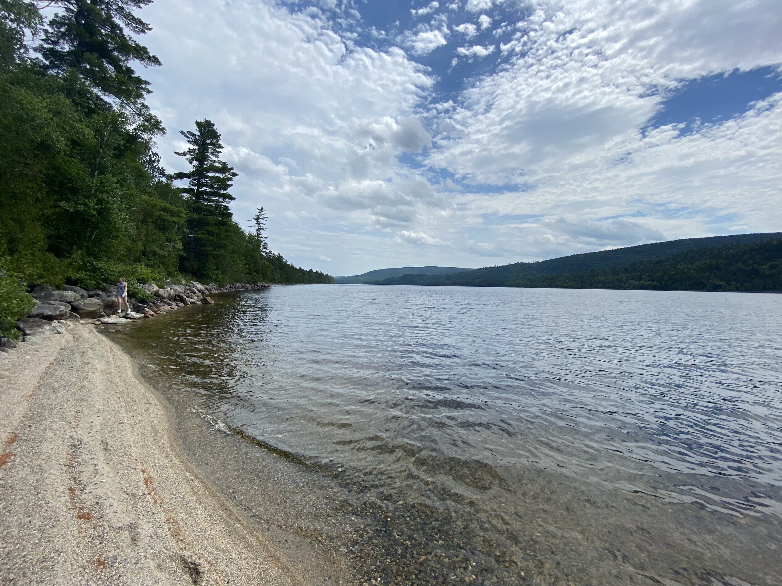
Emma on the beach

Emma cooling off in the lake with Nesuntabunt Mountain in the background
7.5 The trail continues along the lake to its north end. At the marshy area where Rainbow Stream flows into the lake, the trail bears right and leaves the lake.
8.1 Climb gently away from the lake to the bridge over Gould Brook. Turn left and cross the brook, then retrace your steps back to the trailhead.
9.0 Arrive back at the trailhead.

Notice the checker fly in the middle of the frame
This hike passes a lot of water, but in the end it’s a hike about granite. There are miles of ledges and numerous cliffs and boulder fields. That means some nice views and lots of blueberries.